
At the front of the room Ed Butowsky also does a bobblehead nod. Stout, besuited and silver-haired, Butowsky, 47, is a managing partner at Chapwood and a former senior vice president at Morgan Stanley. His bailiwick as a money manager has long been billionaires, hundred-millionaires and CEOs—a club that, the Steinbrenners’ pen be damned, still doesn’t include many athletes. But one afternoon six years ago Butowsky was chatting with Tubbs, his neighbor in the Dallas suburb of Plano, and the onetime Pro Bowl player casually described how money spills through athletes’ fingers. Tubbs explained how and when they begin earning income (often in school, through illicit payments from agents); how their pro salaries are invested (blindly); and when the millions evaporate (before they know it).
“The details were mind-boggling,” recalls Butowsky, who would later hire Tubbs to work in business development at Chapwood. “I couldn’t believe what I was hearing.”
True Story
Me, turning to the man waiting to pay behind me: “Raspberry rum”
Man: “?”
Me, gazing down at the label: “You have such wonderful liquor stores in America….”
Man: “Where are you from?”
Me: “Saskatchewan.”
Man: “Oh, in Canada”.
Me: “Yeah. Where I come from our socialist government owns the liquor stores”.
Man: “Really?”
Me: “They make us line up to buy bread flavoured rum“.
God Rest their Souls
Mathew Halton of the CBC. Direct link.
A virtual tour of the Juno Beach Centre.
Thanks, Boys.
You don’t say!
Most teen drivers don’t like MyKey initially, according to an online survey by Harris Interactive – a finding that should surprise no one. About 67 percent of those polled said they wouldn’t want any of the features.”
“Daddy, Have You Put Out The Fires Yet?”
Forest fire smoke blankets Montreal, Ottawa.
And a whole lot of other places year in and year out that typically, don’t make the news.
h/t Paul.
Make Mine Freedom
h/t Stephen M.
It was a Gore-ious end to the bedding plants
When did Al arrive in the Battlefords?
Cloudy. 60 percent chance of rain showers or flurries changing to 60 percent chance of flurries in the evening. Wind northeast 30 km/h. Low zero.
Gonads, Wallet…

Helvetica
Truths And Myths
The following paid political announcement brought to you by the taxpayers of Toronto.
Domain name: truthsandmyths.ca
Domain status: EXIST
Domain number: 3412626
Approval date: 2010/04/15
Renewal date: 2011/04/15
Updated date: 2010/04/15
Registrar:
Name: easyDNS Technologies Inc.
Number: 88
Registrant:
Name: Toronto Police Service
Number: 53968
Description: Police Services for the City of Toronto
Administrative contact:
Name: Pedja Ljubomirovic
Job Title: Webmaster
Postal address: Toronto Police Service
40 College Street
Toronto ON M5G 2J3 Canada
Phone: +1 (416) 808-7106
Fax: +1 (416) 808-7102
Email: pedja.ljubomirovic@torontopolice.on.ca
Odd. Why not ask CGI Group Inc. to pay for it?
More here from Rafael Gomez.
Update: And now the Toronto taxpayers find their little website used for Liberal Party of Canada ends.
A Woman Needs A Fish Like A Man Needs A Bicycle
Or something like that.
Eyjafjallajökull

“Leave No Doubt”
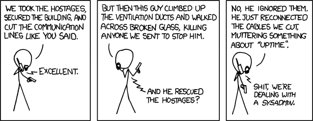
“We took the hostages…”
“Waiting”
Now available in limited edition print. Details here.
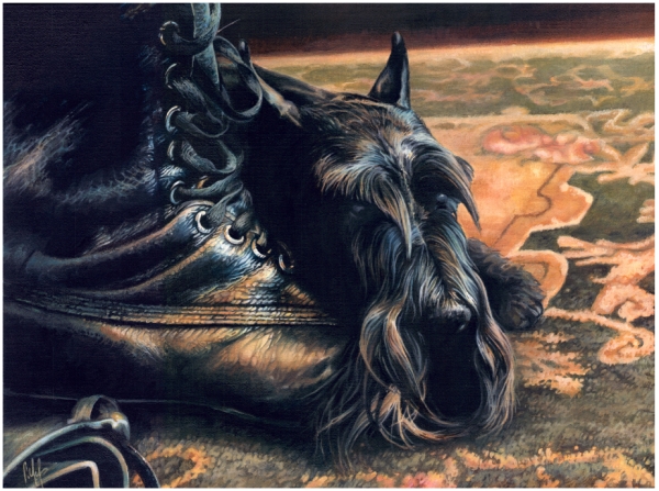
(2009 oil on canvasboard, 12″ x 16″)
All proceeds will go to support the self-sufficient arts in Saskatchewan.
Closing Day: Canada VS USA
Open thread on the men’s hockey final (and the Olympics in general).
GOLD!!!
The nattering “own the podium” critics seem rather quiet of late… somewhere out there a Husky gas station is missing their flag.
The only thing that could spoil this is if there’s drinking after the game.
Heh – “Where was Iggy?” He left after Russia was eliminated.
Via email;
As you probably have noted I’m a very old man who lives in kelowna B.C. I have family yet in Saskatchewan. Yes, I did do a term as Postmaster, Regina a long time ago.
I, as well as most Canadians swelled with pride through out these Olympic games and my heart was glad and the tears did flow. To experience this euphoric National pride was beautiful.
I want to share with you a glimpse of something else that I saw as these games came to a close.
Since 1968 our land and it’s people have been brow beaten into a submisive quiet, almost too humble a land in which National pride was not only frowned upon, but was ridiculed. That lengthy and undeserved humilty was forced upon us by the intellect and bullying of Pierre Elliot Trudeau and the rest of the so called elite who felt they new best.
Today that era has been put to rest. We have now shed that false and pious humility and can take our place as a proud people who have earned the right to stand tall. For this old guy to have been around to see this change has given me a sense of relief.
To finally say goodbye to Pierre and bury him forever is something I only dreamed about.
God bless our Country and thank you to our Olympians for giving us so much.
Yours truly
Mel W.
“It’s not exactly something uncommon in Canada.”
Not yet, anyway.

Heh.
Ontario
Open Thread On Superbowl Results

By inebriated request.
I Want One
When Kai Grundt announced his decision to build the ultimate snowblower from a discarded V8 engine, a friend of his just laughed. So a year later, instead of showing his buddy the finished product, Grundt showed him what it could do….
h/t Allen