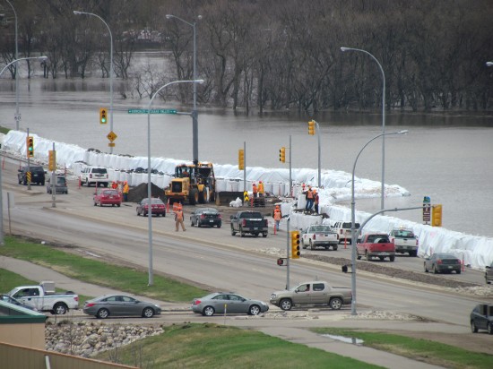
A photo gallery of the Assiniboine River flood at Brandon, MB. Related – Province might not let river spill out. Wishing you all the best of luck, folks.

A photo gallery of the Assiniboine River flood at Brandon, MB. Related – Province might not let river spill out. Wishing you all the best of luck, folks.
Wow, that’s a ton of water. Thank allah that 80% of Manitobans are judeo-Christian Europeans and not …Haitians.
This anthropogenic global climate change drought the experts called for is turning out wetter than expected.
Go figure.
Our mayor was very prepared in Brandon. The provincial government knew of the risk with the Assiniboine and chose to ignore it.
The diversion at Portage is pouring water into Lake manitoba which inturn floods the interlake.
We need sunshine and heat!
“Thank allah that 80% of Manitobans are judeo-Christian Europeans and not …Haitians.”
People are too busy doing volunteer sandbagging to go looting.
I lived in Brandon many years ago (when the big 1997 Red River flood occurred or was it ’96?).
The Assiniboine River Valley is quite deep as it cuts through the City of Brandon. There are a few old houses on “the flats” as they call the bottom of the valley, but for the most part, the City of Brandon is way up on the top of the valley banks on both sides of the river. There is very little chance of a major flood disaster in that city. Some lovely parks along the river’s edge may be inundated, but a major catastrophe ain’t on.
That scene shown in the photo is the one of the two main streets (either 18th Street or 1st) that feed into the City from the transcanada highway. If they can keep the water off of those two streets, and away from the houses at the bottom of the valley banks, the City will be just fine.
It’s when the waters get to the junction of the Assiniboine with the Red at The Forks in central Winnipeg where there might be a big problem. Duff’s Ditch isn’t available to take the water away from the Assiniboine, as far as I recall.
It’s not quite as bad as it is being made out to be. I have seen similar types of flooding when growing up in Brandon. The spring of 1976 was particularly interesting.
The original settlement of Grand Valley was founded in areas that are now currently flooded. Grand Valley was wiped out in a flood in 1881 while Brandon – built on higher ground – avoided the flooding.
The really big issue is connecting over bridges across the river with the highway that bypasses Brandon to the north. The highway is the communities main connection with the outside world.
Most of the flooded areas have been maintained as municipal parks because they do flood quite regularly and urban development has mostly been kept out of the flood-prone bottomlands. Those businesses that do build on the bottomlands are very aware of the risks they are taking. They likely would not receive compensation from the provincial government if they did sustain flood damage.
So why do we have water meters again?
Is there a water shortage that we need to know about?
All snide aside…I sure hope the folks affected get through this the very best they can.
All that water eventually ends up in Hudson’s Bay.
Maybe someone living a little closer to Brandon can clue me in as to which street that is in the picture. If it’s 18th, that’s also a spot on a very long highway (#10) that starts in Texas and ends in Flin Flon.
Louise, I am from S.E. Sask, but Brandon is on of our closer trading centres.
The pic shown is from a new intersection on the North side of the river but at the bottom of the hill on 18th St.
You mentioned you lived in Brandon some time ago. The flat down on the North side of the river has been developed in recent years. East of the picture (left) is a Home Depot, Walmart, etc. along with substantial residential development.
A couple of us farm boys from our area like to go in for the odd Wheat Kings game and I have heard the odd comment as to what would make someone build down in the valley, but…
That being said, there is flooding everywhere on the plains and prayers for all affected are going out from most I’ve talked to.
Our farm is on quite high ground and if flooding ever affects me I’ll be looking for the guy who is building a big boat and rounding up animals. I hear the last guy to do such had a fair number of daughters…
so what’s this? more SDA gloating? more ‘we toed yoo soooo’ to prove how ‘clever’ you all are? hmmmm?
Oh Louise, one more thought.
You mentioned Highway #10. I does indeed go North to Flin Flon (the only town to be named after a fictional character and a rough place to be the away team in hockey, I know!). However it ends and the North Dakota border to the South.
I believe you are thinking of Highway #83. I starts in (giver giver) Swan River and crosses Highway #1 at Virden (45 miles to the west of Brandon) and continues running South all the way to Brownsville Texas, it terminates at the Mexican Border.
Someday I want to ride my motorcycle from one end to the other.
Fay at 11:46 PM
The provincial government knew of the risk with the Assiniboine and chose to ignore it.
The provincial NDP government was busy creating panic in the Red River Valley. They don’t know what they are doing, their forecasting statements have been contradictory, their measurements are out of whack. Compare this with North Dakota were there was fully transparent, highly reliable and timely information.
Here is a link to situation on the ground
So why do we have water meters again?
Is there a water shortage that we need to know about?
Posted by: Oz at May 11, 2011 12:16 AM
If you want to get water from the local creek or pond with a bucket, then it’s still free.
If you want clean potable water piped to your house under pressure, or delivered by truck, then it won’t be free.
Do you have a problem with that?
so what’s this? more SDA gloating? more ‘we toed yoo soooo’ to prove how ‘clever’ you all are? hmmmm?
You having a bad day or something?
North_of_60,
So I’m guessing that in your short life you’ve never lived without a water meter while still having clean potable water piped to your house under pressure.
Good to know about your youth and inexperience.
North_of_60,
So I’m guessing that in your short life you’ve never lived without a water meter while still having clean potable water piped to your house under pressure.
Good to know about your youth and inexperience.
Posted by: Oz at May 11, 2011 1:51 AM
Don’t count on your guessing about the experience of others being worth squat. Just focus on what you think you’re thinking rather than trying to guess about others, or is that too difficult?
You asked So why do we have water meters again?
I answered your question. What’s your problem?
So you know then, North_of_60, that water doesn’t have to be metered.
You also need to know that I never mentioned getting water free, that idea is a product of your fevered imagination.
Do you realize that?
If so, your silly little lesson at 1:42 AM is pointless, as are any other lessons you presume to be able to teach me.
We need Michael ignatieffs thoughts and prayers now more than ever.
OMG. Think of the poor Africans that aren’t getting enough water cause we greedy exploiters are wasting it in floods!!(or some such nonsense a rent seeking twit will tell us)
Oh. And people.It’s definitely a drought that’s producing all this water,or so some AGW nutjob will say,caused by warming. Or is it cooling?
As Biffy would say:
“rise up. rise up. Rise up Assiniboine River! Rise up, and punish those Conservative voters, for not voting LIEberal! Rise up! RISE UP!!!”
Seriously though, I hope that the dam holds … a lot of work went into building it. Thanks T.C. at 12:00 AM for the short history. This way the Global Warming/Climate Change nuts – Elizabeth may – cannot say this is the first time this has happened and that we must tax carbon. Âny excuse will do for carbon tax, according to the Greens.
Well, thanks for derailing the thread, Oz, with your pointless, off-topic ramblings and now pissing match.
The whole west of Manitoba is in trouble. There are huge regions south of the ‘Boine that are potentially going to be sacrificed, but the idiots in charge haven’t told the landowners a damned thing yet.
Up in the Interlake region, Lake Manitoba has spilled the banks for miles, and there’s a 90% possibility that road access will be cut off for a large part of the summer. There’s a lot of ag and cattle in the area, and ranchers are starting to look to other provinces for leased pastures.
We got lucky with the Red and our emergency evac helicopter based at YWG hasn’t been that busy, but it’s still pretty awful.
The whole west of Manitoba is in trouble.
No Yukon Gold. ALL of NDPland is in trouble,and not because of a flood(which happens every year) which neither you or I or anybody else has a damn bit of control over.Sorta like building your house on the side of a volcano,and then bitching you have ash on your roof.
The Irish be bankrupt,
but they know how to fight a flood.
http://www.dizzyboy.com/IrishFlood.jpg
Sorry:
Me and my preview
http://www.dizzyboy.com/jokes/funny-pictures/showfunnypicture.php?image=292
perhaps the point is, even though there is flooding there aren’t many stories (if any) of widespread looting. perhaps the fact that citizens are voluntarily taking part in efforts to combat and minimize the damage caused by the flooding vice crying on national news about how the federal gov’t isn’t doing enough or complaining they have to sleep on a cot in a gym is the point of the post. just a thought
The NDP government should ask the Military to take charge, that’s what they’re trained to do and let the socialists running things run around handing out free needles and other non-essential items.
How much assistance is coming from Pakistan? I’m sure the CBC must be on that.
Our provincial government got caught with their pants down re diking along the Assiniboine this year between Portage and Winnipeg. While the province has poured vast amounts of money into the Red River system, the Assiniboine dyke has not been properly maintained for many years. There were plans to do so, but the province kept delaying them. So early this spring around 300 pieces of equipment tore up property all along the river to slap mud on the dyke, which is far from an ideal solution. Now they’re afraid that it may collapse in some spots anyway. I know of a section of dyke not far from me that has moved 4 feet in the last two weeks. If the dyke breaks, the release of water will be catastrophic, and there will be no time for residents to react.
Justthinkin,
?
Uh, yeah. Thanks for that. Very helpful. Very insightful.
The ‘Boine is at one in 300 years level. Houses miles away from the normal flood plain are being potentially sacrificed with controlled river cuts.
But thanks. Fool.
KMA, Yukon Gold.
I didn’t start any off topic ramblings or pissing match.
Learn to read.
Is the thread derailed?
No.
Are you stupid?
Yes.
I won’t bother trying to explain my first comment on this thread to you.
hint: it has to do with infrastructure and spending priorities.
And who is doing the “controlled” river cuts,Yukon Fool? Oh wait,the dippers in charge.And Oz derailed this thread? For pointing out the obvious?My point still stands,built on a flood plain,expect water,and deep water at that.
To see maps of the areas that may be affected by the ‘controlled” breaching of a dike planned by the Province of MB go to this link:
http://www.gov.mb.ca/waterstewardship/floodinfo/flood_2011.html
And click on the “Controlled/Uncontrolled Releases” and look at LaSalle River Watershed – 1 for the breech point and the start of the potential affected area.
My sympathies.
The Manitoba being so flat you can live WAAY away from one of those rivers and get a nasty surprise from time to time.
Anybody else seen the pictures from that flood inthe 70’s? and the maps of the affected areas. wow.
Louise and Derek, Highway 10 runs to the International Peace Gardens, from which it continues as US281 to the Mexican border at Laredo. Highway 83 runs to the Texas coast from Swan River, but keeps the same number and runs as US83 from the border.
That picture is indeed Highway 10 as it runs south on 18th Street, just north of the riverbank. That was where the last serious flooding cut the highway a few years back. Brandon is far from isolated, but it’s a big pain if the two main routes out of town get cut. There are many other ways to get to the highway but they take you far out of your way.
Wow…what a grumpy bunch today.
Here is an update:
http://winnipeg.ctv.ca/servlet/an/local/CTVNews/20110511/wpg_hoop_holler_110511/20110511/?hub=WinnipegHome
Most disaster planners use the “1 in 100 years” benchmark as a starting point. This flood appears to be a “1 in 300 years” event and I don’t know how you would reasonably plan for that. Overall, I think that things are going to be OK since the cold weather in April slowed down the melt sufficiently to avoid what would have been a major disaster in the entire watershed.
Freekin dumb broad on SunNews this morning called the river the Assina- boney river … for three weeks the bimbos on the Weather Network were calling it the Assani – bi – own reiver ….. communications professionals with colleger degrees to prove it.